
The Baltic Sea, a rich and diverse marine environment, holds immense potential for exploration and sustainable resource management. In this era of technological advancements, one company is making waves with its innovative offering. Introducing Dronelab, a trailblazer in the field of surveying and marine data collection. In this article, we explore how Dronelab’s Multibeam Echosounder technology is revolutionizing operations in the Baltic Sea.
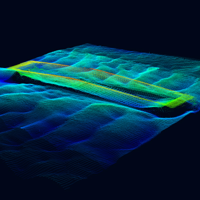
Unleashing the Potential of Multibeam Echosounder Technology: Dronelab’s Multibeam Echosounder technology combines the power of drones with advanced sonar capabilities, offering a groundbreaking solution for hydrographic surveys and underwater mapping. This technology provides a comprehensive and high-resolution view of the Baltic Sea’s seafloor, unlocking new possibilities for navigation, research, and environmental management.
The Multibeam Advantage:
- Unparalleled Data Accuracy: Dronelab’s Multibeam Echosounder system utilizes multiple sonar beams to capture detailed depth measurements and precise bathymetric data. This results in unparalleled accuracy and resolution, enabling precise mapping of underwater terrains, identifying potential hazards, and facilitating safer navigation in the Baltic Sea.
- Rapid and Efficient Data Collection: The integration of Multibeam Echosounder technology with drones allows for swift and efficient data collection over large areas. By harnessing the mobility and versatility of drones, Dronelab’s solution drastically reduces survey time, ensuring up-to-date and comprehensive data for decision-making and planning purposes.
- Real-time Data Processing: Dronelab’s Multibeam Echosounder system includes advanced onboard processing capabilities, providing real-time visualization and quality control of collected data. This feature enables immediate data analysis, allowing stakeholders in the Baltic Sea to make informed decisions promptly, whether in resource management or emergency response situations.
- Environmental Preservation: Dronelab’s Multibeam Echosounder technology promotes sustainable marine practices by facilitating the identification and protection of sensitive ecological areas. By mapping underwater habitats and monitoring changes over time, this solution empowers researchers and environmentalists to make data-driven decisions and contribute to the long-term health of the Baltic Sea ecosystem.
Conclusion: Dronelab’s Multibeam Echosounder technology represents a significant leap forward in marine data collection and analysis in the Baltic Sea. With its unmatched accuracy, efficiency, and real-time processing capabilities, this innovative solution is transforming operations in the region.
By leveraging the power of drones and advanced sonar systems, Dronelab enables stakeholders in the Baltic Sea to navigate safely, plan for sustainable resource management, and conduct cutting-edge research. The company’s commitment to environmental preservation aligns seamlessly with the need to protect and conserve the Baltic Sea’s unique ecosystems.
As Dronelab continues to push the boundaries of aerial surveying and marine data collection, its Multibeam Echosounder technology stands as a testament to the company’s dedication to innovation, quality, and sustainability in the Baltic Sea region.