
Exploring the depths of the Baltic Sea requires cutting-edge technology that can reveal its hidden treasures. Enter Dronelab, a company at the forefront of innovation in marine surveying. With their advanced side scan sonar technology and a range of powerful software tools, Dronelab is revolutionizing operations in the Baltic Sea. In this article, we delve into the details of how Dronelab’s side scan sonar works, and how the captured data is rendered and analyzed using industry-leading software such as Reefmaster, ESRI file format, Global Mapper, Surfer, and Adobe Illustrator.
Dronelab’s Side Scan Sonar Technology:
Dronelab’s side scan sonar technology utilizes sound waves to create detailed images of the seafloor and underwater objects. This cutting-edge technology enables precise mapping, detection of submerged structures, and identification of potential hazards in the Baltic Sea.
Rendering 3D maps for Cross-View Data with Reefmaster
Reefmaster software is a powerful tool that allows for the rendering and analysis of side scan sonar data. It provides a user-friendly interface, enabling users to interpret the collected data, create detailed maps, and generate reports. Reefmaster’s advanced features, such as mosaic creation and target identification, enhance the visualization and analysis of the Baltic Sea’s underwater landscape.
Utilizing ESRI File Format for Spatial Analysis
ESRI file format, commonly used in Geographic Information Systems (GIS), is highly compatible with Dronelab’s side scan sonar data. By leveraging this format, Dronelab enables users to perform spatial analysis, overlay data with other geographic information, and extract valuable insights about the Baltic Sea’s marine environment. ESRI’s suite of GIS software, including ArcGIS, allows for sophisticated analysis and informed decision-making.
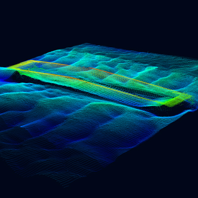
Analyzing Data and creating cross view with Global Mapper
Global Mapper software serves as an essential tool for analyzing side scan sonar data captured by Dronelab. This powerful GIS application enables users to perform detailed terrain analysis, volume calculations, and 3D visualization. Global Mapper’s intuitive interface and extensive data processing capabilities contribute to a comprehensive understanding of the Baltic Sea’s underwater topography.
Creating Stunning Visualizations with Surfer and Adobe Illustrator
Surfer software, renowned for its 3D visualization and contour mapping capabilities, plays a vital role in transforming Dronelab’s side scan sonar data into stunning visual representations. Surfer enables users to create detailed bathymetric maps, cross-section profiles, and visually appealing 3D renderings. Furthermore, Adobe Illustrator, a versatile vector graphics software, provides additional flexibility for refining and enhancing visualizations generated by Surfer, allowing for the creation of professional-quality maps and reports.
Conclusion
Dronelab’s side scan sonar technology, in conjunction with powerful software tools such as Reefmaster, ESRI file format, Global Mapper, Surfer, and Adobe Illustrator, is revolutionizing marine surveying and data analysis in the Baltic Sea. By capturing detailed underwater images and leveraging sophisticated software capabilities, Dronelab empowers Latvian organisations to make informed decisions, protect the marine environment, and unlock the secrets of the Baltic Sea’s hidden world.
Through the seamless integration of advanced technology and industry-leading software, Dronelab is driving innovation in marine exploration and resource management. By utilizing the full potential of Reefmaster, ESRI file format, Global Mapper, Surfer, and Adobe Illustrator, Dronelab enables stakeholders to visualize and analyze the Baltic Sea’s underwater landscape with unparalleled accuracy and detail.
References:
Novatoriska daudzstaru eholota tehnoloģija operācijām Baltijas jūrā