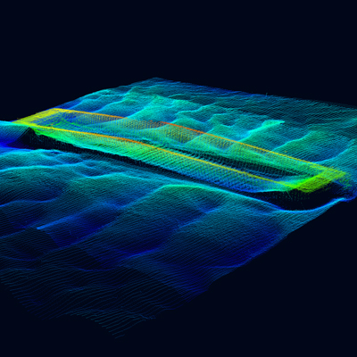
Bathymetry is the process of measuring and mapping the underwater features of oceans, rivers, lakes, and other bodies of water. Surveying the bed of water bodies is a critical task that requires advanced technology and expertise. In recent years, drones have revolutionized the field of bathymetry and surveying. Among the top companies in this field is Dronelab, whose specialists are renowned for their high-quality work. In this article, we will explore why Dronelab is the best choice for professional surveying work.
The Importance of Bathymetry:
Bathymetry is crucial for a variety of applications, including coastal zone management, navigation safety, infrastructure development, and environmental monitoring. Bathymetric data is used to create accurate and detailed maps of underwater features, such as depth contours, seafloor topography, and substrate composition. This information is vital for understanding the geomorphology of aquatic environments, predicting water circulation patterns, and identifying potential hazards.
Why Choose Dronelab?
Dronelab is a leading provider of drone-based surveying and mapping services. Their specialists are experts in the use of unmanned aerial vehicles (UAVs) and other cutting-edge technologies to collect and process bathymetric data. Here are some of the reasons why Dronelab is the best choice for professional surveying work:
- Advanced Technology: Dronelab uses state-of-the-art equipment, such as multibeam sonar systems, to collect high-resolution bathymetric data. These systems are capable of producing accurate maps of the seafloor, even in challenging environments.
- Expertise: Dronelab specialists have extensive experience in bathymetric surveying and mapping. They are trained to operate complex equipment, interpret data, and create detailed maps of underwater features.
- Efficiency: Dronelab’s drone-based surveying services are highly efficient. They can quickly collect large amounts of data and process it in real-time, allowing clients to make informed decisions in a timely manner.
- Safety: Dronelab prioritizes safety in all of their operations. Their specialists are trained to operate equipment in compliance with all relevant regulations, and they use a range of safety measures to ensure that their work is conducted without incident.
Conclusion:
In conclusion, bathymetry is a critical field that requires advanced technology and expertise. Dronelab is a top provider of surveying and mapping services, and their specialists are the best choice for professional bathymetric work. They use cutting-edge equipment, have extensive experience, are highly efficient, and prioritize safety. If you need accurate and detailed maps of underwater features, Dronelab is the company to choose.
References:
- “Bathymetry: The Art of Measuring Water Depth.” National Oceanic and Atmospheric Administration, 2019.
- “Dronelab – Services.” Dronelab, 2021.
- “Multibeam Sonar Systems.” Teledyne Marine, 2021.
- “Bathymetry: Mapping the Seafloor.” Schmidt Ocean Institute, 2021.
- “The Role of Bathymetry in Coastal Zone Management.” International Hydrographic Organization, 2018.
Humor:
“Why did the drone take a bath?” “To get a better understanding of bathymetry, of course!”