Bathymetry / Hydrography Services
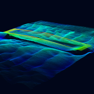
Unlock detailed insights into underwater environments with our advanced drone-based Bathymetry and Hydrography services. We specialize in accurately mapping the depth and underwater topography of lakes, rivers, ponds, reservoirs, and near-shore zones. Utilizing cutting-edge unmanned systems equipped with specialized sonar sensors (such as single-beam or multi-beam echosounders), we generate precise, high-resolution maps of submerged terrain and underwater features.
Why Utilize Drone Technology for Hydrographic Surveys?
Traditional bathymetric surveys often require manned vessels, which can be costly, time-consuming, and impractical or unsafe in shallow, remote, or obstructed waters. Our drone-based approach offers distinct advantages:
- Precision Mapping: Capture accurate depth measurements and detailed underwater features for reliable data.
- Rapid Deployment & Survey: Cover significant areas quickly, accelerating project timelines compared to conventional methods.
- Unmatched Accessibility: Effortlessly survey shallow water bodies, confined areas, and locations difficult or hazardous for traditional boats to reach.
- Cost Efficiency: Reduce expenses associated with vessel mobilization, large field crews, and operational time.
- Integrated Surface & Subsurface Data: Combine bathymetric data seamlessly with aerial mapping (photogrammetry/LiDAR) for comprehensive 3D site models.
Critical Data for Diverse Applications:
- For Construction, Engineering, and Environmental Consultancies: Accurate underwater data is essential for planning and executing projects involving water bodies.6 Obtain precise bathymetric maps for infrastructure design (bridges, pipelines, docks), dredging volume calculations, erosion monitoring, site assessments, habitat mapping, and pre/post-construction surveys.7 Make critical decisions with confidence, based on detailed and reliable subsurface information.
- For Government Agencies, Port Authorities & Research Institutions: Effective management and understanding of water resources rely on up-to-date hydrographic data.8 Utilize our services for updating navigational information for inland waterways, monitoring sedimentation in reservoirs and rivers, assessing water storage capacity, mapping floodplains, studying coastal change, characterizing aquatic habitats, and supporting scientific research. Enhance resource management, infrastructure planning, and environmental protection efforts with efficient and precise underwater mapping.9